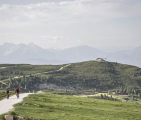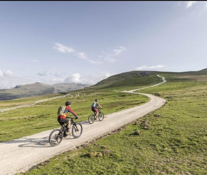
Mountainbike-Tour II - Oberbozen - Rittner Horn
A long and very rewarding tour from the mountain station of the Ritten cable car in Oberbozen through light-flooded forests and meadows to the panoramic mountain Rittner Horn.
Mountainbike
Always on wide forest and alpine paths, you reach Riggermoos to Tann and on to Pemmern. From there, the traffic-calmed road leads to Rosswagen and through stone pine forests to Schönalm and along the beautifully laid out alpine path to the summit of the Rittner Horn at 2,260 m, where a unique panoramic view opens up.
Directions
The MTB tour starts in Oberbozen at the mountain station of the Rittner cable car and follows the road in a westerly direction (sign and marking no. 2), at the fork in the road by the shops slightly uphill to Zagglermoos and left through the small commercial zone to the start of the "Wald-Wild-Wunder-Weg". Here you turn left into the Stauseeweg (family hiking trail no. 16 is a pushing trail for bikers) to the "Lobishof". Continue along the wide hiking trail (marking no. 18A) to the "Bacherle", past the "Moserhof" to the country road (be careful at the junction). Turn right here and follow the road for approx. 100 m to the bus stop in Riggermoos. Now cross the road to the left and walk moderately steep (marking no. 6) through the sparse "Gunggelwald" forest to the Tann. At the "Tann" bus stop, follow the road with little traffic or the flanking footpath (marking no. 1) to Pemmern.
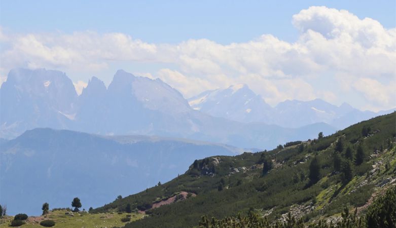
At the collective car park at the valley station of the mountain railway, follow the traffic-calmed municipal road (marking no. 7) to the Rosswagen and turn right into the forest. At the barrier, the alpine pasture path begins (marker no. 4), which leads rather steeply up to the "Schön Alm". Here a magnificent panorama opens up, from the western Dolomites, to the Brenta and Ortler groups, to the Ötztal Alps. The alpine path now gently ascends to the "Unterhorn" and "Feltuner" huts. At the Feltuner hut, head uphill (marker no. 2, use the pasture grate to pass through - keep the fence gate closed!). At the next fork, keep to the right (another fence gate) until you reach the fork below a sheep barn. Here you stay on the wide access path in the direction of the radio transfer station (no marking, signpost) just before the summit of the Rittner Horn to the Rittnerhornhaus (2,260 m), the destination of the tour. The descent follows the ascent route. Please set a respectful pace.
At the collective car park at the valley station of the mountain railway, follow the traffic-calmed municipal road (marking no. 7) to the Rosswagen and turn right into the forest. At the barrier, the alpine pasture path begins (marker no. 4), which leads rather steeply up to the "Schön Alm". Here a magnificent panorama opens up, from the western Dolomites, to the Brenta and Ortler groups, to the Ötztal Alps. The alpine path now gently ascends to the "Unterhorn" and "Feltuner" huts. At the Feltuner hut, head uphill (marker no. 2, use the pasture grate to pass through - keep the fence gate closed!). At the next fork, keep to the right (another fence gate) until you reach the fork below a sheep barn. Here you stay on the wide access path in the direction of the radio transfer station (no marking, signpost) just before the summit of the Rittner Horn to the Rittnerhornhaus (2,260 m), the destination of the tour. The descent follows the ascent route. Please set a respectful pace.
Description to arrive at destination
From Bolzano to Klobenstein Ritten, 18 km
Parking
Parking, 39100 Bolzano, valley station, Rittner Straße 12
Author's tip
Rispetto - rispetto - rispetto! Sulle piste ciclabili per MTB del Renon valgono la correttezza e la tolleranza nei confronti della parte più debole del percorso. Ci auguriamo una collaborazione rispettosa tra mountain biker, escursionisti e ciclisti. Grazie mille!